The National Weather Service (NWS) in Burlington has officially confirmed that a tornado rated as EF-1 touched down near Lincoln Road in West Woodstock at 2:40 p.m. last Thursday, June 18. The twister tracked east-northeast across West Woodstock into Bridgewater before lifting near River Road.
According to a field survey conducted by NWS technicians, the tornado followed a path estimated at 6.8 miles in length from the touchdown point 0.6 miles east of Woodstock Village to the end location 0.6 miles east/southeast of Bridgewater Village. The NWS surveyors determined that the maximum path width of the Woodstock/Bridgewater tornado was 300 yards. The touchdown lasted for 14 minutes from 2:40 until 2:54 p.m. on June 18.
An EF-1 (Enhanced Fujita) tornado rating officially classifies a tornado as producing moderate damage with estimated three-second gust wind speeds between 86 and 110 miles per hour. The NWS reported that peak winds of the Woodstock/Bridgewater tornado clocked in at 105 miles per hour.
The Standard has a full report on the tornado and the damage incurred in Woodstock and Bridgewater in its June 25 edition.
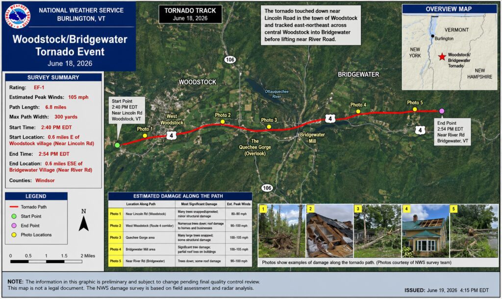
A tracking map that accompanied the NWS survey report includes five photos showing damage at various locations along Route 4. The report is based on both the field assessment by the NWS surveyors and radar analysis. Photo Courtesy of The National Weather Service